I decided to leave my RV in Buena Vista and travel around Colorado to visit 4 National Parks and 2 State Parks with just my truck and camping gear (1400 miles round trip). I didn’t realize it when I started my trip, but the National Park system was celebrating 100 years.
Here’s a map that shows the general route I took.

My first stop, August 25th, was at the Great Sand Dunes National Park & Preserve, which is just 2 hours south of Buena Vista. The tallest dunes in North America are located here amid a diverse landscape of grasslands, wetlands, conifer and aspen forests, alpine lakes, and tundra. The dunes spread across 30 square miles and were formed tens of thousands of years ago as wind funneled towards 3 mountain passes here – Mosca, Medano, and Music Passes. The winds blow from the valley floor toward the mountains, but during storms – the winds blow back toward the valley. These opposing wind directions cause the dunes to grow vertically.


After spending a few hours hiking over the dunes I headed west to Mesa Verde National Park. Mesa Verde, Spanish for green table, offers a spectacular look into the lives of the Ancestral Pueblo people who made it their home for over 700 years, from AD 600 to 1300. Today the park protects nearly 5,000 known archeological sites, including 600 cliff dwellings. The cliff dwellings of Mesa Verde are some of the most notable and best preserved in the North American Continent.
Sometime during the late 1190s, after primarily living on the mesa top for 600 years, many Ancestral Pueblo people began living in pueblos they built beneath the overhanging cliffs. The structures ranged in size from one-room storage units to villages of more than 150 rooms. While still farming the mesa tops, they continued to reside in the alcoves, repairing, remodeling, and constructing new rooms for nearly a century. By the late 1270s, the population began migrating south into present-day New Mexico and Arizona. By 1300, the Ancestral Puebloan occupation of Mesa Verde ended.
I drove to Wetherill Mesa – which is the “quieter side” of the park. I enjoyed a self-guided tour of the “Step House” then went on a paid tour of the “Long House” (only $4). After the Long House tour I walked out the Nordenskiold Site #16 Trail that overlooks more fascinating cliff dwellings.


I found a spot to set up my tent on BLM land just a few miles from the park. The next morning I headed north to Black Canyon of the Gunnison National Park. The drive on CO-145 and CO-62 was breathtaking and, stopping to take pictures right before the town of Ridgway, I chanced to meet Larry and Marianne Williams who were gracious enough to offer me their cabin for the night. Thank you! They were the NICEST people and I didn’t want to leave! Their property was just beautiful. I ended up staying 2 nights and took the time to explore the area – plus I was able to get my “dog fix” with their 2 labs: Mandy and Lacie.
My first stop was at the Yankee Boy Basin and Twin Falls – it’s at the end of a 4 wheel drive road that leads out of Ouray. I then drove up the Million Dollar Highway (US 550), in the rain, to Silverton and did part of the Greater Alpine Loop up to Animas Forks and the California Gulch. Of course I didn’t think to leave my kayak with the Williams’ so I got some strange looks and a few jokes from other 4 wheel enthusiasts.
I then backtracked down the Million Dollar Highway because I wanted to experience the terror of the highway without the rain. *laughs
“Though the entire stretch has been called the Million Dollar Highway, it is really the twelve miles (19 km) south of Ouray through the Uncompahgre Gorge to the summit of Red Mountain Pass which gains the highway its name. This stretch through the gorge is challenging and potentially hazardous to drive; it is characterized by steep cliffs, narrow lanes, and a lack of guardrails; the ascent of Red Mountain Pass is marked with a number of hairpin curves used to gain elevation, and again, narrow lanes for traffic—many cut directly into the sides of mountains.”


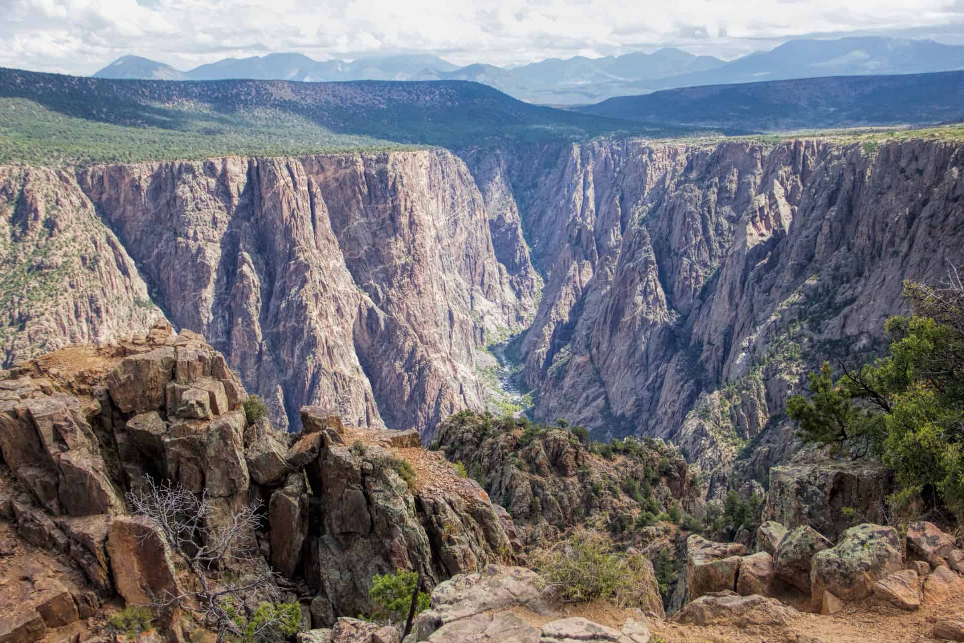
After leaving the Williams’, I continued on to the Black Canyon of the Gunnison National Park. The park has some of the steepest cliffs, oldest rock, and craggiest spires in North America. With two million years to work, the Gunnison River, along with the forces of weathering, has sculpted this vertical wilderness of rock, water, and sky.
The park is separated into the North Rim and the South Rim. I began at the South Rim entrance and traveled along the paved road to the end where you can hike to Warner Point – an easy 1.5 mile (round trip) hike. I then took the road down to the river – which has a 16% grade and lots of twits and turns. After talking to a ranger, I decided to drive 2 hours to the North Rim entrance (less busy and no paved roads in this part of the park) and stayed the night in the campground there. It’s a small campground and you can walk from your site right to the edge of the canyon in a few hundred feet.
The next morning I drove to the end of the north road and hiked Deadhorse Trail and the loop that also goes along the canyon. It was a 6.5 mile round trip hike and I had the whole place to myself!


After spending the night in Grand Junction with a couple I met years ago, I stopped at my first state park – Rifle Falls State Park. It’s a small park and I didn’t stay long – just a quick hike on the trail that goes up and over the falls.

My second stop was at Sylvan Lake State Park in Eagle Colorado. I’m not sure why Colorado calls these “lakes” – I’d call them “ponds”. My original plan was to kayak here but it was much smaller than I thought it would be. That’s NOT to say it wasn’t a very pretty area. I did set up camp here but the sounds of logging trucks at 5am ruined the peace and quiet.

Next stop? Rocky Mountain National Park. I realized half way through my trip that ending up in RMNP right before the Labor Day weekend probably wasn’t my smartest idea. It’s the 3rd most visited park in the US too. Now, most people who know me know I HATE crowds – so I decided on just driving through the park rather than spending much time here.


My final stop was in Denver, where I stayed the night with some dear friends, before driving the final 2.5 hours home.


